Übersicht
Zuletzt aktualisiert 2026-09-28
Schwierigkeitsgrad C
Gesamtzeit
4 hrs
Ansatz 2 hrs
Klettern 10 mins
Ausfahrt 2 hrs
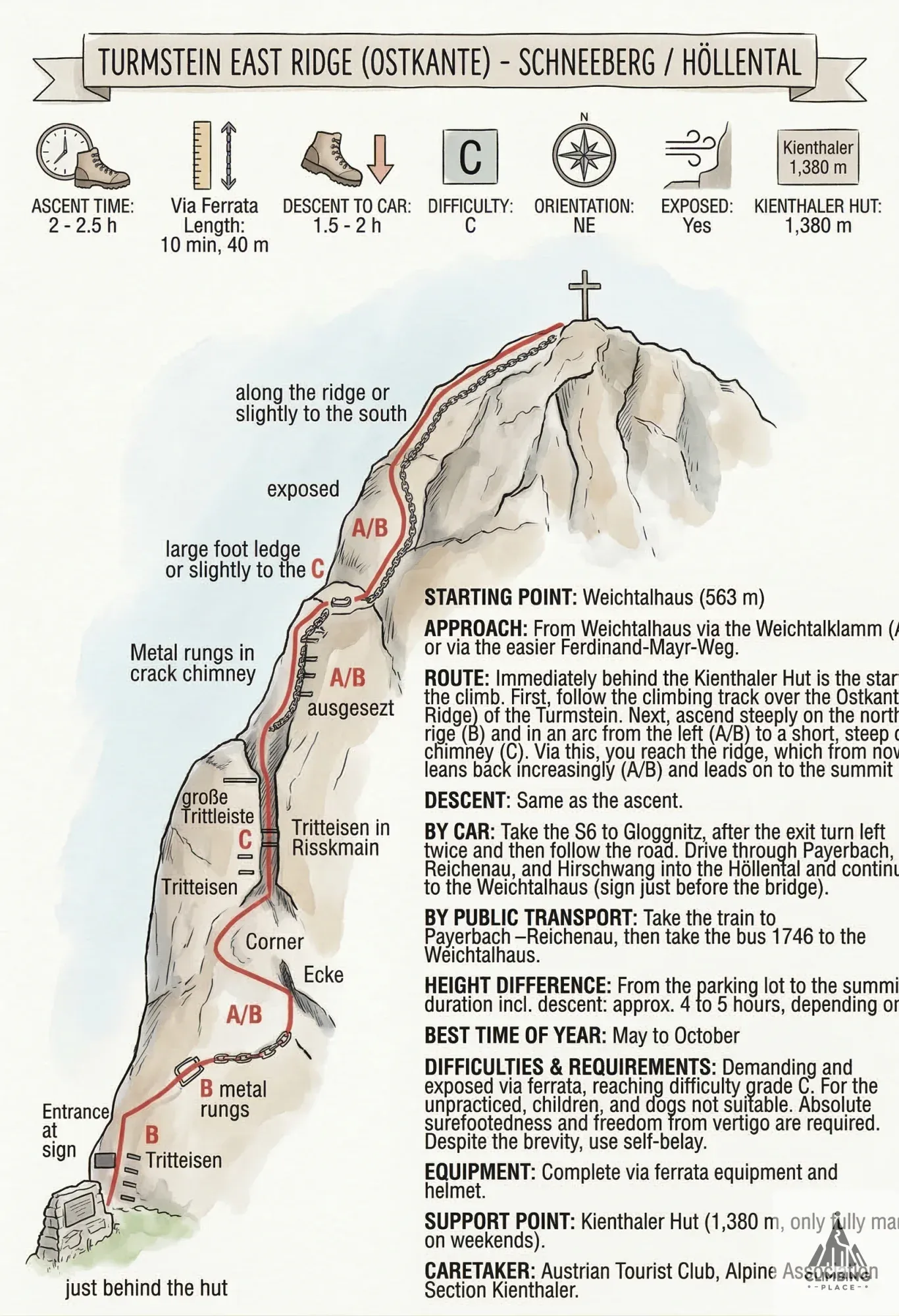
Image Kletterrouten-Topo Zum Öffnen klicken
Klettersaison
Keine Kletterbeschränkungen gefunden
- Geöffnet
- Eingeschränkt
- Unbekannt
Jan Feb Mar Apr May Jun Jul Aug Sep Oct Nov Dec
Gemeinschaft
Helfen Sie mit, diese Seite zu verbessern
Sei der Erste, der diese Route einträgt.
Schwierigkeit
C
Dauer
4 hrs
Ansatz 2 hrs
Klettern 10 mins
Ausfahrt 2 hrs
Kabellänge
35 m
Höhengewinn
870 m
Höhe
1,383 m
Typ
Klettersteig
General Information
The ascent of the 1,416m-high Turmstein is made via the challenging and exposed East Ridge via ferrata. Unlike the more sheltered Kienthaler Hütte approach, the East Ridge offers a direct and rewarding panoramic view towards the Rax, Schneealpe, Mürzsteger, and Türnitzer Alps.
Character and Special Features: This via ferrata must also be used for the descent.
Securings: Chain, Iron Rungs.
Start Point: Weichtalhaus (563 m).
Directions and Route
Approach: From Weichtalhaus via the Weichtalklamm (gorge) (difficulty A/B) or the easier Ferdinand-Mayr-Weg trail.
Route: The entrance to the via ferrata is located immediately behind the Kienthaler Hütte. The route leads steeply up on the north side of the ridge (B), then in a bow from the left (A/B) to a short, steep crack chimney (C). From there, you reach the ridge, which from now on leans back increasingly (A/B) and continues to the summit.
Descent: Same as ascent.
Logistics
Travel by Car: Take the S6 to Gloggnitz. After the exit, turn left twice and follow the road through Payerbach, Reichenau, and Hirschwang into the Höllental. Continue to the Weichtalhaus (parking is available just before the bridge).
Travel by Public Transport: Take the train to Payerbach-Reichenau, then take Bus 1746 to Weichtalhaus.
Best Season: May to October.
Stützpunkt (Base): Kienthaler Hütte (1,380 m), managed on weekends only.
Safety Requirements
Gear: Full via ferrata kit (harness, set, helmet) is required.
Difficulties & Requirements: This is a challenging and exposed via ferrata reaching difficulty C. It is not suitable for untrained individuals, children, or dogs. A high level of absolute surefootedness and a lack of giddiness (Schwindelfreiheit) is essential, despite the short length. Continuous self-belaying is mandatory.
Entdecken Sie Turmstein O-Kante, einen Klettersteig mit der Bewertung C. Der versicherte Abschnitt ist 35 Meter lang und führt auf eine Höhe von 1383 Metern. Planen Sie insgesamt ca. 4 hrs ein, wobei der Klettersteig selbst etwa 10 Minuten in Anspruch nimmt. Prüfen Sie aktuelle Bedingungen, sehen Sie das Topo an oder laden Sie eigene Fotos für Turmstein O-Kante hoch.
Wettervorhersage
Wetter wird geladen...
Aktuelle Bedingungen
Keine Bedingungsmeldungen in den letzten 30 Tagen.
Noch keine Einträge — teile, was du weißt, damit der nächste Kletterer leichter startet.
Rezensionen 0
Bist du hier geklettert?
Melden Sie sich an, um Ascent anzumeldenNiemand zum Klettern?
Autor
Unbekannt