Skip to content
Offline You are offline — showing a saved version of this page.
A new version is available.
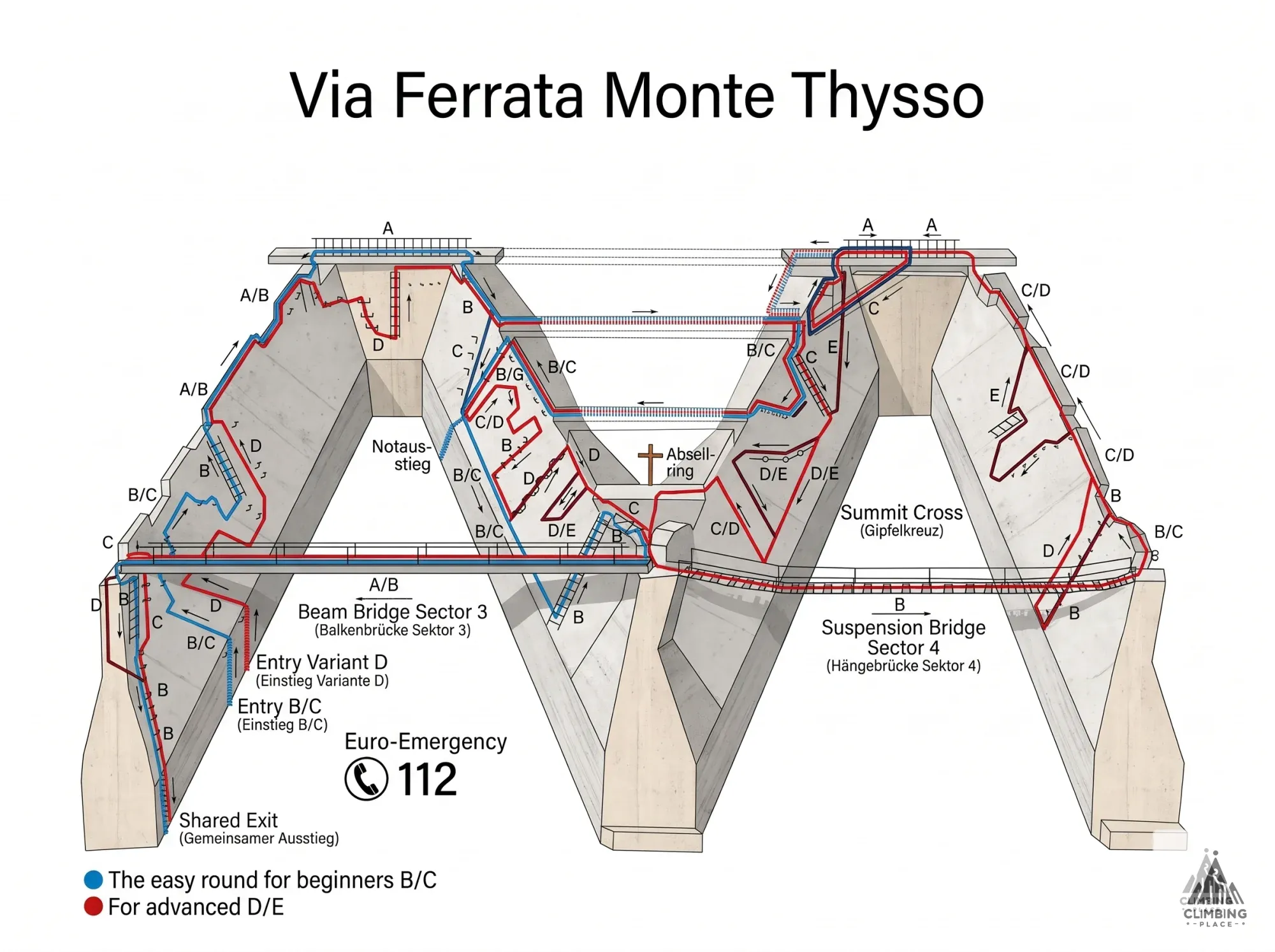
Topo of Via Ferrata Monte Thysso var. D/E (D/E), Lower Rhine Plain
< Back to List

Via Ferrata Monte Thysso var. D/E, Lower Rhine Plain D/E

Germany, Lower Rhine Plain

D/E

Last updated 2026-10-27

Grade D/E
Total Time
1 hour
Approach 10 mins
Climb 1 hour
Exit 10 mins
Image Route Topo Click to open
Route Topo Click to open

Climbing season

No climbing restrictions found

  • Open
  • Restricted
  • Unknown
Jan Feb Mar Apr May Jun Jul Aug Sep Oct Nov Dec
Community

Help improve this page

Be the first to log this route.

Difficulty
D/E
Duration
1 hour
Approach 10 mins
Climb 1 hour
Exit 10 mins
Cable Length
380 m
Elevation gain
12 m
Altitude
29 m
Type
Via Ferrata
Location

51.48285, 6.78118

Parking 285 m

51.48098, 6.78400

Discover Via Ferrata Monte Thysso var. D/E, a Via Ferrata rated D/E. The cable section spans 380 meters in length, leading to a peak altitude of 29 meters. Plan for a total adventure time of approximately 1 hour, with the main ferrata ascent taking about 60 minutes. Check the latest condition reports, view the topo map below, or join the community to add your own photos for Via Ferrata Monte Thysso var. D/E.

Weather forecast

Live 3-day weather forecast for this place and an estimate of whether the rock is dry enough to climb today, updated every hour.

Current conditions

No condition reports in the last 30 days.

No logs yet — add what you know so the next climber has an easier start.

Reviews 0
Have you climbed here?
0 people bookmarked this place
Share this route

Send it to the person you want to climb it with.

WhatsApp Facebook

Nobody to climb with?

Author

Unknown

Similar ferratas nearby (around grade D/E)
D/E
Berchtesgaden Alps (Bavaria) Topo
D/E
Berchtesgaden Alps (Bavaria) Topo
D/E
Wetterstein Mountains (Bavaria) Topo
E
Saxon Elbe Valley Topo
D
Chiemgau Alps Topo
Other ferratas in Lower Rhine Plain
B/C
Lower Rhine Plain Topo