Aperçu
Dernière mise à jour 2026-03-14
Saison d'escalade
Aucune restriction d'escalade trouvée
- Ouvert
- Limité
- Inconnu
Aidez-nous à améliorer cette page
Soyez le premier à enregistrer cet itinéraire.
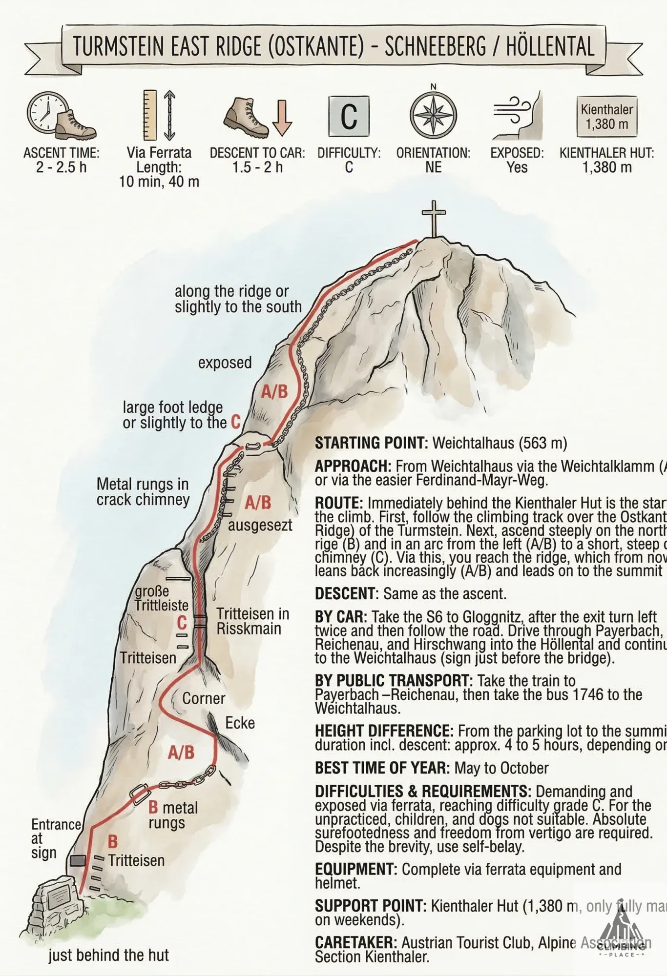
The ascent of the 1,416m-high Turmstein is made via the challenging and exposed East Ridge via ferrata. Unlike the more sheltered Kienthaler Hütte approach, the East Ridge offers a direct and rewarding panoramic view towards the Rax, Schneealpe, Mürzsteger, and Türnitzer Alps.
Character and Special Features: This via ferrata must also be used for the descent.
Securings: Chain, Iron Rungs.
Start Point: Weichtalhaus (563 m).
Directions and Route
Approach: From Weichtalhaus via the Weichtalklamm (gorge) (difficulty A/B) or the easier Ferdinand-Mayr-Weg trail.
Route: The entrance to the via ferrata is located immediately behind the Kienthaler Hütte. The route leads steeply up on the north side of the ridge (B), then in a bow from the left (A/B) to a short, steep crack chimney (C). From there, you reach the ridge, which from now on leans back increasingly (A/B) and continues to the summit.
Descent: Same as ascent.
Logistics
Travel by Car: Take the S6 to Gloggnitz. After the exit, turn left twice and follow the road through Payerbach, Reichenau, and Hirschwang into the Höllental. Continue to the Weichtalhaus (parking is available just before the bridge).
Travel by Public Transport: Take the train to Payerbach-Reichenau, then take Bus 1746 to Weichtalhaus.
Best Season: May to October.
Stützpunkt (Base): Kienthaler Hütte (1,380 m), managed on weekends only.
Safety Requirements
Gear: Full via ferrata kit (harness, set, helmet) is required.
Difficulties & Requirements: This is a challenging and exposed via ferrata reaching difficulty C. It is not suitable for untrained individuals, children, or dogs. A high level of absolute surefootedness and a lack of giddiness (Schwindelfreiheit) is essential, despite the short length. Continuous self-belaying is mandatory.
Découvrez Turmstein O-Kante, une Via Ferrata classée C. La section de câble s'étend sur 35 mètres de longueur, conduisant à une altitude maximale de 1383 mètres. Prévoyez une durée totale d'aventure d'environ 4 hrs, l'ascension de la ferrata principale prenant environ 10 minutes. Consultez les derniers rapports de condition, consultez la carte topographique ci-dessous ou rejoignez la communauté pour ajouter vos propres photos pour Turmstein O-Kante.
Prévisions météorologiques
Conditions actuelles
Aucun signalement de conditions dans les 30 derniers jours.
Pas encore d’ascensions — ajoutez ce que vous savez, pour que le prochain grimpeur parte plus facilement.
Avis 0
Avez-vous grimpé ici ?
Connectez-vous pour vous connecter à AscentPersonne avec qui grimper ?
Auteur
Inconnu
Via ferrata similaires à proximité (vers la classe C)

Trouvez votre prochain projet grâce à notre vaste base de données d'itinéraires et de problèmes de bloc. Recherchez par…